UAV Services
FAA-certified pilots and experienced engineers delivering aerial inspection, LiDAR mapping, and optical gas imaging for energy infrastructure
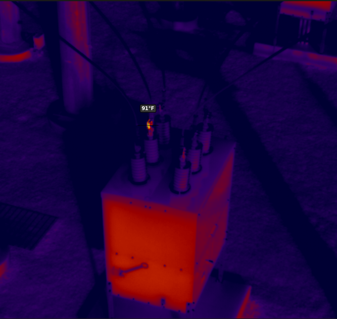
Thermal Inspection
Our drone-mounted infrared cameras detect hot spots, loose connections, and overloaded components across substations, power lines, and facility equipment. Thermal data is delivered with georeferenced reports so your maintenance team can prioritize repairs before minor issues escalate into outages.
Visual Inspection
High-resolution aerial imagery lets us document equipment condition, structural defects, and clearance violations across your infrastructure — without scaffolding, bucket trucks, or equipment shutdowns. Deliverables include annotated photo reports and video flyovers for stakeholder review.
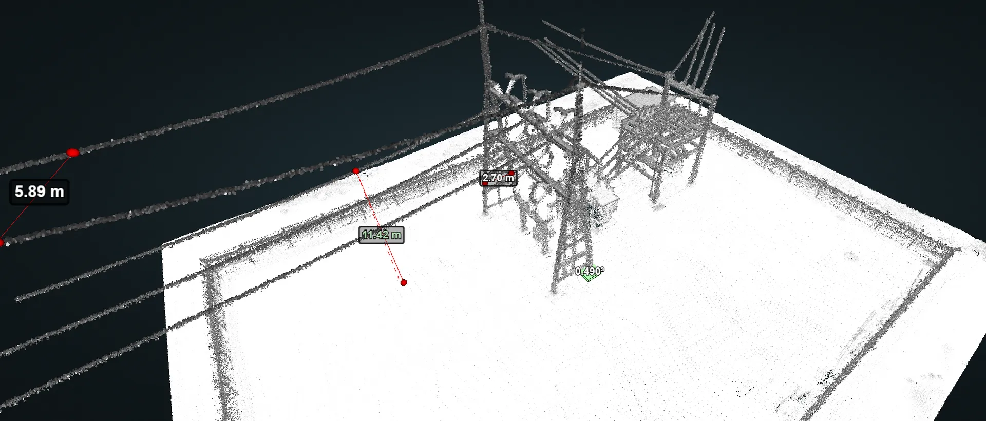
LiDAR Mapping
Our UAV-mounted LiDAR sensors capture dense 3D point clouds for corridor mapping, terrain modeling, and vegetation management. Combined with our in-house survey and engineering teams, we deliver finished products — not raw data — including surface models, planimetric maps, and PLS-CADD-ready survey files.
UAV Services
Lythix operates a fleet of industrial drone platforms equipped with thermal, visual, LiDAR, and OGI sensors. Every mission is planned and flown by FAA-certified pilots with deep energy-industry experience, and all data is processed in-house by our survey and engineering teams.
Our industrial drone platforms carry inspection-specific sensors — thermographic and high-resolution visual — to deliver reliable assessments while reducing false positives. We specialize in:
- Power line and transmission corridor inspections
- Substation thermal and visual surveys
- Wind farm and solar farm inspections
- Pipeline right-of-way monitoring
- Tank battery and facility assessments
UAV-mounted LiDAR paired with our in-house survey and engineering teams means you receive finished, field-ready products — not raw data packages. We process dense 3D point clouds into digital terrain models, planimetric maps, vegetation analyses, and PLS-CADD-ready survey files.
Aerial LiDAR is ideal for transmission corridor mapping, route surveys, volumetric calculations, and terrain modeling where centimeter-level accuracy is required.
After storms, equipment failures, or other incidents, our UAV teams deploy rapidly to assess damage across power lines, substations, pipelines, and facilities. Using BVLOS (Beyond Visual Line of Sight) capabilities, we can survey large areas without putting personnel in hazardous conditions.
Deliverables include georeferenced photos, thermal scans of damaged equipment, and OGI flights for leak verification — all shared with your operations and insurance teams in near real-time.
Our aerial platforms capture centimeter-level orthoimagery and GIS data for planning, construction, and ongoing maintenance of industrial sites. Deliverables include orthomosaic maps, digital elevation models, and GIS-ready feature layers.
With flexible launch-and-recovery requirements, we can mobilize to remote locations and cover large areas efficiently — making aerial asset mapping practical even for sites that are difficult to access by ground.
Scheduled and on-demand aerial patrols help you identify unauthorized access, equipment tampering, and signs of material theft across remote infrastructure. Our drones capture time-stamped, georeferenced imagery that can be compared flight-to-flight to flag changes in equipment, fencing, or site conditions.
This approach covers more ground than vehicle patrols and provides documented evidence for investigations and insurance claims.
Our OGI-equipped drones use specialized cooled-sensor cameras to detect and visualize hydrocarbon and volatile organic compound emissions in real time. Aerial OGI surveys cover wellheads, tank batteries, compressor stations, and gathering lines faster and more safely than ground-based methods.
Results support EPA and state LDAR compliance programs, methane reduction initiatives, and operational leak management — with georeferenced reports delivered for each survey.
Schedule a UAV Inspection
Thermal imaging, LiDAR mapping, OGI, and aerial asset inspections — delivered by FAA-certified pilots with energy sector expertise.